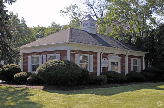
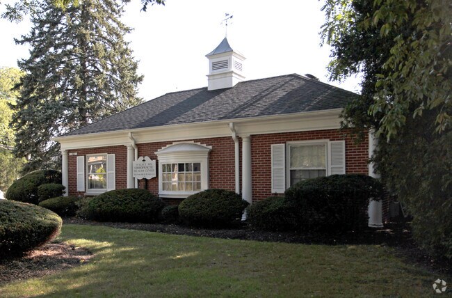
Property Record
201 Walnut Ave, Cranford, NJ 07016
NEARBY LISTINGS FOR SALE OR LEASE
Property Detail
201 Walnut Ave
Newark, NJ-PA
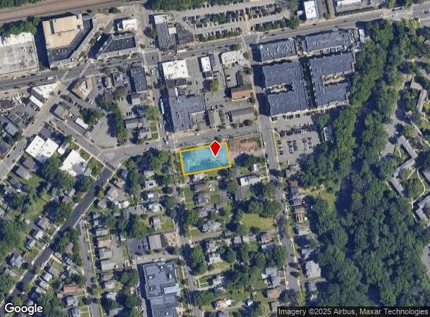
Boundry Survey Plan
03-00484-0000-00019-01
Union
Financialbuilding
New Jersey
AE
19.1
34013C0150F
0.85 AC
2024
Parkway Cranford Corridor
2025
Northern New Jersey
037200
DEMOGRAPHICS near 201 Walnut Ave
1 Mile
3 Mile
5 Mile
2024 Total Population
18,863
158,037
435,181
2029 Population
18,549
156,139
429,743
Pop Growth 2024-2029
(1.66%)
(1.20%)
(1.25%)
Average Age
42
41
40
2024 Total Households
7,280
57,680
154,996
HH Growth 2024-2029
(1.90%)
(1.31%)
(1.33%)
Median Household Inc
$134,219
$108,665
$100,380
Avg Household Size
2.50
2.70
2.70
2024 Avg HH Vehicles
2.00
2.00
2.00
Median Home Value
$606,167
$472,363
$454,609
Median Year Built
1950
1955
1956
Nearby Places
Map Layers
Map Styles
 Street
 Aerial
- Restaurants
- Banks
- Shops
- Fitness
- Groceries
PUBLIC TRANSPORTATION
COMMUTER RAIL
Cranford (Raritan Valley Line - NJ Transit Commuter Rail (NJ Transit))
DRIVE
WALK
Distance
Cranford (Raritan Valley Line - NJ Transit Commuter Rail (NJ Transit))
1 min
4 min
0.2 mi
Garwood (Raritan Valley Line - NJ Transit Commuter Rail (NJ Transit))
DRIVE
WALK
Distance
Garwood (Raritan Valley Line - NJ Transit Commuter Rail (NJ Transit))
3 min
1.3 mi
AIRPORT
Newark Liberty International
DRIVE
WALK
Distance
Newark Liberty International
17 min
11.9 mi
LaGuardia
DRIVE
WALK
Distance
LaGuardia
51 min
31.1 mi
John F Kennedy International
DRIVE
WALK
Distance
John F Kennedy International
56 min
37.3 mi
Freight Ports
New York Container Terminal
DRIVE
WALK
Distance
New York Container Terminal
17 min
9.9 mi
SALE & LEASE HISTORY
LISTING DATE
SALE/LEASE

Sep 25, 2016
For Lease
Apr 05, 2017
For Sale
Nearby Properties
Address
Land Use
TOTAL SIZE
Lot Size
Zoning
Address
Land Use
TOTAL SIZE
Lot Size
Zoning
Address
Land Use
TOTAL SIZE
Lot Size
Zoning
107.41 AC
Address
Land Use
TOTAL SIZE
Lot Size
Zoning
Address
Land Use
TOTAL SIZE
Lot Size
Zoning
31,905 SF
0.18 AC
Address
Land Use
TOTAL SIZE
Lot Size
Zoning
Address
Land Use
TOTAL SIZE
Lot Size
Zoning
10.11 AC
Address
Land Use
TOTAL SIZE
Lot Size
Zoning
8.43 AC
Address
Land Use
TOTAL SIZE
Lot Size
Zoning
29.03 AC
IL
Address
Land Use
TOTAL SIZE
Lot Size
Zoning
151.20 AC
O
Address
Land Use
TOTAL SIZE
Lot Size
Zoning
3,538 SF
112 AC
Address
Land Use
TOTAL SIZE
Lot Size
Zoning
10.82 AC
H
Address
Land Use
TOTAL SIZE
Lot Size
Zoning
9.42 AC
Address
Land Use
TOTAL SIZE
Lot Size
Zoning
159,434 SF
11.93 AC
IL
Address
Land Use
TOTAL SIZE
Lot Size
Zoning
19.90 AC
P
Address
Land Use
TOTAL SIZE
Lot Size
Zoning
182 SF
13.80 AC
Address
Land Use
TOTAL SIZE
Lot Size
Zoning
17,416 SF
19.42 AC
Address
Land Use
TOTAL SIZE
Lot Size
Zoning
Address
Land Use
TOTAL SIZE
Lot Size
Zoning
10.15 AC
RA
Address
Land Use
TOTAL SIZE
Lot Size
Zoning
56,476 SF
141.63 AC
Address
Land Use
TOTAL SIZE
Lot Size
Zoning
4.13 AC
Address
Land Use
TOTAL SIZE
Lot Size
Zoning
3.87 AC
CG
Address
Land Use
TOTAL SIZE
Lot Size
Zoning
Address
Land Use
TOTAL SIZE
Lot Size
Zoning
31,002 SF
3.64 AC
Address
Land Use
TOTAL SIZE
Lot Size
Zoning
Address
Land Use
TOTAL SIZE
Lot Size
Zoning
224.81 AC
Address
Land Use
TOTAL SIZE
Lot Size
Zoning
8.77 AC
Address
Land Use
TOTAL SIZE
Lot Size
Zoning
8.84 AC
Address
Land Use
TOTAL SIZE
Lot Size
Zoning
10.16 AC
Address
Land Use
TOTAL SIZE
Lot Size
Zoning
7.63 AC
Address
Land Use
TOTAL SIZE
Lot Size
Zoning
The World's #1 Commercial Real Estate Marketplace
Connect with us
© 2025 CoStar Group
The information above has been obtained from sources believed reliable. While we do not doubt its accuracy we have not verified it and make no guarantee, warranty or representation about it. It is your responsibility to independently confirm its accuracy and completeness. Any projections, opinions, assumptions, or estimates used are for example only and do not represent the current or future performance of the property. The value of this transaction to you depends on tax and other factors which should be evaluated by your tax, financial, and legal advisors. You and your advisors should conduct a careful, independent investigation of the property to determine to your satisfaction the suitability of the property for your needs.